Research Projects
Interaction of Coastal and Freshwater Systems
The overarching goal of this study is to develop a quantitative understanding of the coupling between Louisiana’s coastal zone and the upstream freshwater basins that feed it under the impacts of climate change and increasing water demands by various societal users. Water management strategies that adapt to these changes in the upper catchments will influence the quantity and quality of fresh surface water that ultimately flows into coastal systems. Conversely, what happens in the coast has major implications for the upper catchments and the communities that live there. The study uses data and modeling-based approaches to assess the linkages and feedbacks between the upstream basins and the coastal zone.
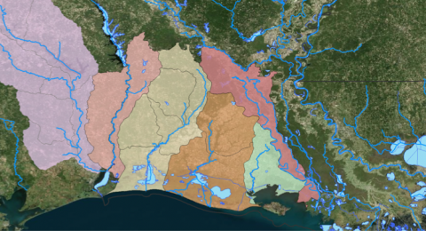
(Chenier Plain upper catchments that connect to the coastal zone, from left to right: Neches, Sabine, Calcasieu, Mermentau, Vermillion, Teche.)
Community-Scale Flood Monitoring
The Louisiana Watershed Flood Center is working with the Acadiana Planning Commission on designing a regional-scale flood monitoring system that serves the needs of the seven parishes of Acadiana. Check out the preliminary design for the system that has been developed.
A revised design and implementation phases will be developed as part of the community effort to improve real-time flood monitoring and warning applications.
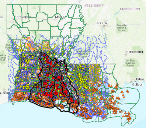
(Preliminary Design of Acadiana-Wide Flood Monitoring Network (http://nexus.hydroviz.org/Lessons/Index/LA/AcadianaMonitoring))
WRF-Hydro Modeling in Low Gradient Catchments
The Weather Research and Forecasting Model Hydrological modeling system (WRF-Hydro) is a community-based, open source model developed by the National Center of Atmospheric Research (NCAR) to link multi-scale process models of the atmosphere and terrestrial hydrology. In this study, we develop a WRF-Hydro for a local catchment in south Louisiana, Coulee Mine, to evaluate its predictive skills in low-gradient basins. One of the main research goals is to assess different schemes for terrain and channel routing (e.g., diffusive wave) and compare to other models that allow for full dynamic solutions and how they all perform in capturing complex flow regimes such as downstream effects and interbasin exchanges.
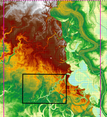
(The WRF-Hydro model is based on a high-resolution Lidar digital elevation model for parts of the Vermilion River Basin and its tributaries)
Linking the National Water Model to Local Flood Models
The National Water Center (NWC) developed the National Water Model (NWM) to provide stream discharge forecasts at more than 2.7 million channels and stream segments across the US. The objective of our study is to examine the regional and local utility of the NWM for flood applications that typically take place at local counties and municipalities, and how outputs from the NWM can support local engineering-type models and extend the power of the NWM for flood analysis at community-level scales. The study is performed for a pilot-scale local basin in Lafayette, Louisiana, a region with typical low-gradient topography and frequent extreme flood events.
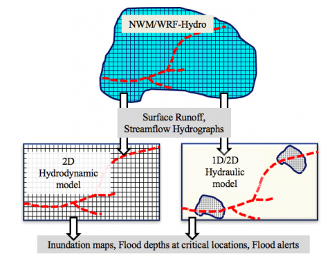
(Schematic representation of possible linkages between the NWM and local flood models)
Analysis of Surface and Groundwater Stress in Louisiana
Water resources are increasingly being overdrafted in the Southeastern U.S., despite abundant rainfall and the apparent availability of surface water. Using the state of Louisiana as an example, this study quantifies the stresses on water resources on a fine watershed scale by performing a water balance analysis between the availability of and demands for surface and groundwater. Water demand includes environmental flows, as well as public supply, rural domestic, industrial, power generation, agricultural, and aquaculture sectors. These results have implications for identifying new opportunities for reallocation of surface water use to reduce groundwater pumping and improve water sustainability in the region. (ERL Publication)
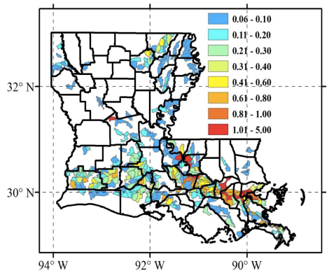
(Annual-average water stress in Louisiana at a HUC12 spatial scale (Eldardiry et al., 2016))
Using Radar-Rainfall Data for Precipitation Frequency Analysis
The high spatio-temporal resolutions of radar-based multi-sensor Quantitative Precipitation Estimates (QPEs) makes them a potential complement to the gauge records for engineering design purposes, such as precipitation frequency analysis. This study investigates three fundamental issues that arise when radar-based QPE products are used in frequency analysis: (a) Effect of sample size due to the typically short records of radar products; (b) Effect of uncertainties present in radar-rainfall estimation algorithms; and (c) Effect of the frequency estimation approach adopted. The study uses a 13-year dataset of
hourly, 4 4 km2 radar-based over a domain that covers Louisiana, USA. (J. Hydrology Publication)
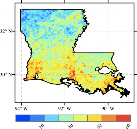
(Spatial distribution of radar-based hourly Mean Annual Maxima (MAM; mm/h) during the study period (2002–2014). Eldardiry et al., (2015))
Memories of the 2016 Floods
This project (part of a larger study on Louisiana response to recent disaster) records and preserves individual and community memories of the 2016 Louisiana Floods. It includes oral
history interviews about the Floods and their effect on various communities in Louisiana that were taken at community collection events. The interviews collected provide valuable insight
into how Louisianans react to disasters such as floods and how these disasters shape individuals and communities years after their impact. For more information see: Skilton, L., A. Horowitz, and C. Parker. (2017). “Disasters Have Histories”: Teaching & Researching American Disasters. The American Historian.
http://tah.oah.org/february-2018/disasters-of-histories-teaching-and-researching-american-disasters/
Online Tool to Teach Students About Energy-Water Nexus
Interactions between food production, energy production, and water supplies, usually referred to as the food-energy-water (FEW) nexus, are critically important to sustaining society. Two components of this nexus, energy and water, are strongly interrelated: generating electricity and refining fuel require us to use water; pumping, delivering, and treating water require us to use energy. Links between the energy and water systems are expected to intensify in the future. Therefore, it is important to understand and foster continued attention to the interdependency between these systems. To address this need, we have developed a Web platform and a pilot learning module focusing on energy and water in an effort to address EW nexus educational needs. The HydroViz Nexus platform can be used in upper-level undergraduate and graduate courses that deal with water resources and sustainability topics within disciplines such as civil engineering and geosciences. The tool is developed in collaboration with the Sandia National Lab. (EOS Article)
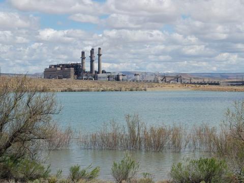
(Power plants are often located near sources of freshwater that they use for cooling purposes. A new online educational resource helps students explore the interactions between power generation systems and water resources. Picture Credit: Vincent C. Tidwell (Habib et al., 2017))
HydroViz: Active Learning in Hydrology & Water Resources
Sponsored by several grants from NSF, our team has developed the HydroViz student-centered platform to support active learning in the field of Hydrology by creating case-based, data and simulation-driven learning experiences beyond traditional methods typically used in today’s classrooms. HydroViz developments are informed by well-proven educational research on active learning strategies and leverages recent research advances on monitoring and modeling of complex hydrologic systems to develop a suite of flexible and adaptable learning modules. The modules are located within three US regional-scale systems (Coastal Louisiana, Rocky Mountains, Utah, and Florida Everglades) to allow the introduction of large-scale hydrologic processes and their connections to human activities.

(Homepage of the HydroViz project, showing locations of the different student learning modules in Louisiana, Utah, and Florida (www.hydroviz.org))
Advancing Flood Monitoring and Modeling in Coastal Low‐Gradient Watersheds Using Unmanned Aerial Vehicle [UAV] Technologies
This project is sponsored by the Louisiana Board of Regents Industrial Ties Research Subprogram (ITRS) to pursue a collaborative project between UL Lafayette and three Louisiana-based industry partners, Fenstermaker, Jesco, and Louisiana UAV Specialties LLC. The overall motivation of this project is to enhance flood resilience of local communities by exploring the feasibility of emerging technologies in Unmanned Aerial Vehicles (UAV), and multirotor drones in particular, to (a) supplement existing flood monitoring techniques, and (b) advance our understanding of complex processes that take place in low-gradient watersheds prone to extreme flooding. The focus will be on small to midsize rivers and streams that lack adequate in-situ measurements, and where traditional remote sensing technologies are unable to provide the desired spatial details. Currently, the use of UAVs is booming in the fields of agriculture and industrial inspection. However, the environmental and engineering industries are not taking full advantage of UAV capabilities in the field of streamflow monitoring. This might be attributed to the fact that only a few research studies have been done to establish standard methodologies for UAV-based river flow data collection and estimation, and how such information can be incorporated in existing monitoring and modeling efforts. Our project will pave the way for new UAV low-cost techniques that address the problem of scarcity of in-situ flood monitoring resources.
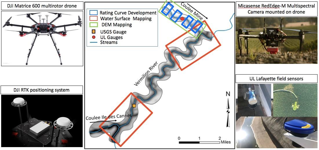
(A schematic showing our study area, the Vermilion River and two of its tributaries Coulee Mine, and Coulee Ile des Cannes. The outside panels of the graphic depict some of the instruments which we will use over the course of the project.)
Diagnostic analysis of complex flow dynamics in transitional watersheds in coastal Louisiana: Assessment of NWM performance and future enhancements using in-situ observations and multi-model simulations
Therefore, the main objective for this project is to conduct a diagnostic evaluation of the performance of the National Water Model (NWM) in simulating complex flow dynamics in low-gradient transitional watershed environments through a combined data analysis and hydrologic-hydraulic modeling approach. Our pilot study sites are within the Vermilion River and its tributaries, located in Lafayette, south-central Louisiana. Our analysis will be conducted using independent records of tributary-scale streamflow and stage observations that our team collected at different locations across our study area, in combination with a number of hydraulic models that cover the watershed’s main river and its major tributaries. Our evaluation analysis will examine the retrospective record of the NWM predictions, and will also include new hydrologic and hydraulic modeling where we will link outputs from the NWM (both retrospective output as well as new NWM simulations) to engineering-type hydraulic models that are capable of simulating physically complex river flow scenarios.
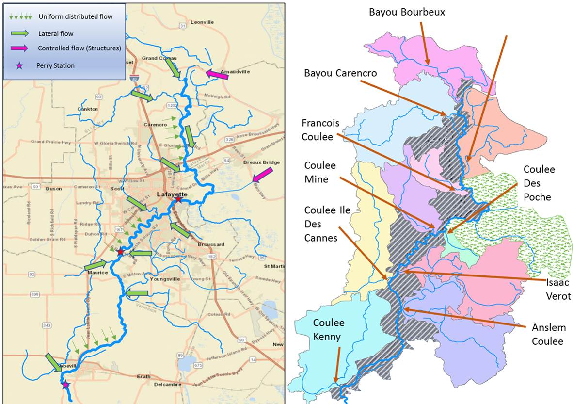
(A schematic showing our study area the Vemilion River and all its tributaries (right panel). On the left panel we show how we plan to model the incoming flows from the coulees into the Vermilion using the NWM outputs)
Flood Forecast Portal
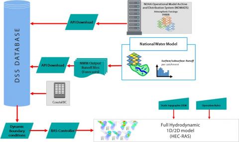
(A schematic showing the structure of the UL Flood Forecasting system.)
UL Flood Forecast Portal is a modular forecast execution and data visualization platform developed for the Vermillion River in southwest Louisiana (and applicable anywhere). The portal allows detailed hydraulic models such as HEC-RAS to be combined with hydrologic models or data and used in an operational forecast capacity. The forecasting system takes advantage of pre-generated hydrologic forecasts produced by national forecasting system (the National Water Model), but can also be coupled with local watershed-specific hydrologic models (e.g., HEC-HMS). UL Flood Forecast Portal achieves this modularity using a service-oriented architecture and machine-to-machine application programming interfaces (APIs) to allow efficient and cost-effective model execution using a variety of computing resources. Using these modern software approaches allows UL Flood Forecast Portal to be quickly adapted to new hydraulic and hydrologic modeling frameworks and rapidly applied to novel model domains.
Operational systems for flood forecasting are typically implemented regionally for medium to large rivers (ca. 10,000+cfs mean annual flow). These systems do not provide forecasts for small rivers (ca. 1,000cfs and below) and their tributaries. National-scale efforts that include forecasts for these smaller rivers (e.g. National Water Model) have difficulty providing accurate forecasts, especially in low-relief coastal watersheds of the Gulf Coast. In such situations, more sophisticated model structures and numerical approaches (e.g. unsteady diffusive or dynamic wave; operation of hydraulics structures) are required. To fill this gap in local-scale forecasting capabilities we are developing the UL Flood Forecast Portal.
You can check out the UL Flood Forecast Portal here
To learn more, see this presentation as well as these articles:
Saad, H.A., Habib, E.H., and Miller, R.L.. 2020. "Effect of Model Setup Complexity on Flood Modeling in Low‐Gradient Basins." Journal of the American Water Resources Association 1– 19. https://doi.org/10.1111/1752-1688.12884. https://onlinelibrary.wiley.com/doi/abs/10.1111/1752-1688.12884
Saad, H., E. Habib (2021): Assessment of Riverine Dredging Impact on Flooding in Low-Gradient Coastal Rivers Using a Hybrid 1D/2D Hydrodynamic Model. Frontiers in Water. Vol. 3. Doi:10.3389/frwa.2021.628829. https://www.frontiersin.org/articles/10.3389/frwa.2021.628829/full